↓
JAVASCRIPT IS DISABLED. Please enable JavaScript on your browser to best view this site.
Carrollton Land Surveying
Search for:
...serving the Carrollton, Georgia & Carroll County area...
Carrollton Land Surveying
Home
ALTA Title Survey
Boundary Surveying
Construction Survey
Drone LiDAR Mapping
Elevation Survey
Land Surveying
Lot Survey – Mortgage Survey – Closing Survey
Topographic Survey
Blog
Contact Us
Home
→
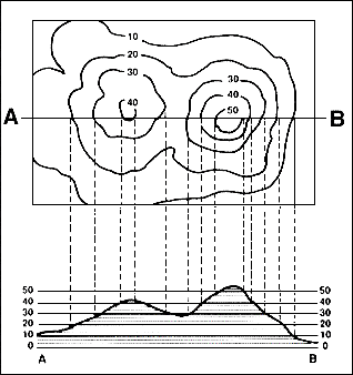
topo surveying
→
Explanation of a Topo Surveyor
→
topo_survey_contours
Image navigation
← Previous
Next →
topo_survey_contours
Published
November 3, 2012
at
318 × 338
in
Explanation of a Topo Surveyor
Image navigation
← Previous
Next →
↑