GPS and Land Surveying

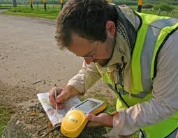
Land surveying is a profession that greatly utilize the GPS system.

land surveying

Today, man-made constellations are in orbit. Their purpose is to provide instant, exact and global positioning information. This global positioning system of GPS is revolutionizing the modern construction sites, automating and guiding land surveying equipment, providing instantaneous circles and volume gap, simplifying total and controlled surveys. Nearly everyone involved in the land surveying and construction industry has heard something about satellite positioning technology or maybe you or someone you know is already using it. Whether an operator or a casual observer, there are still many questions about how this exciting system really works.

These positioning satellites don't stay in one place like the stars; they orbit the earth about twice a day. Constantly transmitting uniquely identified radio signals that can be perceived by specialized units on earth. These signals are used to precisely measure the distance to the receiving instrument from each satellite visibly overhead.

Just as stars have exact locations in the sky, the locations of the GPS satellites are also defined, becoming orbiting reference points. Using a process based on triangulation, a GPS receiver processes the signals from multiple satellites to compute an accurate position on Earth, which is why it is widely use in land surveying.

For mobile applications that require high accuracy, such as three dimensional machine control, there are two requirements that must be met. First, the signals from a minimum of five satellites must be received at all times. And second, those five satellites must be distributed across the sky. This is called Dilution of Precision or DOP. The simple rule of thumb is this, the more satellites received the better your system will perform.

land surveying

All land surveying receivers incorporate standard GPS tracking technology; unfortunately the GPS satellite constellation alone cannot continuously make the minimum requirement of accurate mobile positioning. For any given location, there are times in a day when there are less than five available satellites or very poor DOP.

Now, consider a land surveying job site with trees, buildings, or other obstructions when satellite receptions are easily be further reduced. All land surveying GPS receivers suffer this same problem because they all use the same satellites to operate.

Even the planned signal modernization to the GPS satellites won't solve this problem. An obstruction that blocks one signal blocks all signals from that satellite. A land surveying equipment provider has solved this problem. The solution isn't adding more signals from the same satellites; it's adding more satellites.

Today, there is a second positioning satellite constellation in operation, the Glonass System. This positioning system is operated and maintained by the Russian government; much like the GPS is operated and maintained by the United States government; combining these two satellite constellations give land surveyors access to 38 different satellites; 14 more than a GPS-only system.

The additional satellites mean stronger and more accurate positions and better performance in obstructed land surveying areas. These additional satellites mean maximum up time in all land surveying locations, in all conditions.

For an up to date and accurate land surveying service, contact Carrollton Land Surveying at (470) 729-1411 or better yet, you may fill out our contact form request and a licensed land surveyor will contact you. 

The Essence of Land Surveying

According to research, land surveying has existed ever since the beginning of recorded history. They believe that it has long been used in making the great pyramids; in which historians believe to be very accurate in the calculation of its land area. It was also used in ancient Egypt in re-establishing lost land boundary markers whenever Nile River overflowed its banks. Finally, historians believe that prominent people back then created this practice in order to have refined sharing of the lands they own.

land surveying

Also, there are verses in the Bible that support the practice of land surveying

  •  Proverbs 22:28 Do not move the ancient boundary, which your fathers have set. 
  •  Deuteronomy 19:14 "You shall not move your neighbor's boundary mark, which the ancestors have set, in your inheritance which you will inherit in the land that the Lord your God gives you to possess.
  • Deuteronomy 27:17 'Cursed is he who moves his neighbor's boundary mark.' And all the people shall say, 'Amen.' 

Now what does land surveying really mean?

Land surveying basically means measuring and mapping lands. It is the science of accurately calculating the land’s area; determining the points of distance between a land and another. The actual purpose of this is to establish land maps and set boundaries for ownership. It is commonly used in the execution of nearly every form of construction.  The system of land surveying has proved itself to be a very important factor in the development of human environment as the earth’s surface continues to change according to the lifestyle of people.

land surveying

Just imagine a world where people freely claim an area of land for their benefit without even thinking of the others. Imagine people crossing over another person’s land because there are no borders that would express the ownership of anyone. Imagine people building any construction they want in any land they prefer. Or just simply imagine your neighbors removing your fences. If this happens, it would lead to chaos. That is why land surveying has been made to follow.

The importance of land surveying is identical to its purpose. It is responsible in the establishment of the maps of every city, region, country, continent or the earth itself. Through this system, there would be definite borders blocking any people from owning what another person owns. With this procedure, the distribution of the vast space of land would be fair enough. Everything would be organized and regulated.  This would mean that the buildings, railroads and even our houses would be made without having any complications if it had undergone land surveying.

As you can see in books, magazines, websites and other things that contain information about our world’s structure, we can see that there are boundaries which separate one place from another. This diminishes the complications in the ownership of lands among people. Since humans tend to get selfish, it is best to have everything in order, up to the issue of allocating land areas for everyone. This is the real essence of land surveying.

Call Carrollton Land Surveying today at (470) 729-1411  or fill out a contact form request for more information concerning your land surveying needs.

Things to Know When Building Your House

Land Surveying in Building your house

land surveying

It is a very good idea to build your home because you will be able to get exactly what you want instead of when you buy. Of course, you may need to add some things or you may not know what you are getting yourself into.

It is a huge decision choosing the right builder since it is one of the largest personal investments that you will make. Be sure to give an interview to all of the possible contractors and then pick the one that will help make your dream home come true. While you are talking to the possible contractors be sure you ask all of the pertinent questions that will help you choose the best; their how long they have been in the business, experience,  what are the kind of buildings that they have experience building and it would be great if you can see some of their work. It is also crucial to pick house plans which may lead to a good home now and in the future. This is something that your contractor should be able to help you with and they may call on the services of an architect.

Budget in building your house

Before to planning your house design consider these factors; your budget, the size of the home to be built, location of the home, wall finishes, design features that you would like, ceiling height, number of stories, fixture types, exterior finishings, also your time frame. 

If you happen to be uncertain about any of these items, your contractor or architect should be able to guide you through this very important process. They will help you choose the details that are right for you down to the very smallest detail. They may refer you to other consultants for things like finishes, colors, and the like so be prepared to sit and discuss with them for a few hours to talk about all these choices that you may have.This is the reason that your choice of a builder is important. 

If your builder isn't able to advise you on home location they should refer you to a real estate agent. A real estate agent is familiar with important details like neighborhood home values, school districts, traffic issues, funding options, etc.

Land Surveying: avoids future problems

Another stop you should make is to see a land surveyor. Land surveyors are trained and experienced in identifying features of the land that might have an impact on your new home – called land surveying. Some of these features are flood zones, property line encroachments from neighbors, lot dimensions, and building setbacks. Land surveyors are measurement experts. And, since your home is your most valuable asset, land surveying should be one of your first steps in any new construction.

Avail Land Surveying service from your local surveyor:

Call Carrollton Land Surveying today at  (470) 729-1411   or fill out a contact form request for more information concerning your land surveying needs.